App Detial

Natural Atlas: Outdoor GPS & Offline Hiking Maps
Seller: Natural AtlasPrice: -1


Download Natural Atlas: Outdoor GPS & Offline Hiking Maps free via AppsHawk.
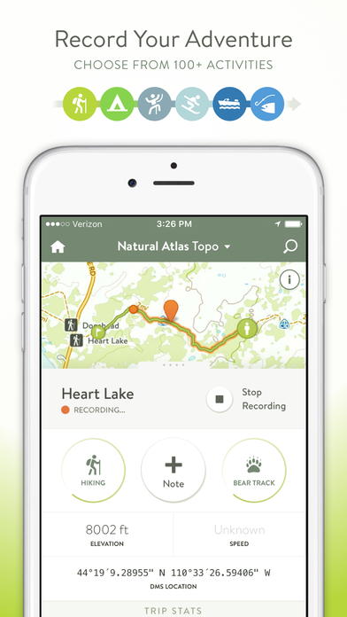
A beautiful, evolving map of the outdoors in your pocket. Natural Atlas is the ultimate GPS for your adventures: track & plan your trips – whether you’re into hiking, backpacking, cycling, boating, birding, or something less-common like foraging. Take geo-tagged photos, stay organized with 45,000+ note presets, record 100+ activities, and more.
A free Natural Atlas account is required to use the app. Recordings sync to your online profile & private recordings are available via an in-app upgrade.
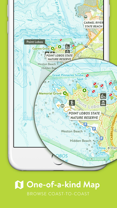
â– THE MAP
The Natural Atlas Topo is a one-of-a-kind map of the United States outdoors you won’t find anywhere else on the App Store. It’s continually evolving and will improve with your use. It’s especially-polished in the Western USA. Browse online for free: https://naturalatlas.com
â– FEATURES
– Powerful, yet simple
– Works Offline
– 100+ Color-Coded Activities
– Switch Activities while Recording (e.g. Driving to Boating to Hiking)
– Stay Organized with 45,000+ Note Presets (Wildlife Species, Plants, Rocks & Minerals, and more)
– Browse 1000’s of Campgrounds, Boat Launches, Waterfalls, Hot Springs, Arches, and more (search everything on the map)
– Advanced Search: “SF Hikesâ€, “Giant Sequoias in Yosemiteâ€, “Boat Ramps on Yellowstone Riverâ€, “Oregon Beach Accesses†(internet required)
– Take Geo-Tagged Photos
– Speed, Distance, and Elevation Stats
– Star Places as “Been Toâ€, “Want To Go Toâ€, or “Like†– Keep a to-do list of places you want to visit
– Follow Friends and members of the community to keep tabs on their outdoor adventures
– Note Segments: highlight difficult climbing pitches, animal tracks you’re following, etc
– Explore Thousands of Guides from high-quality publishers on the web. Find the right guide, then click through to their website (opens in your web browser)
– Import GPX Files on NaturalAtlas.com
And more…
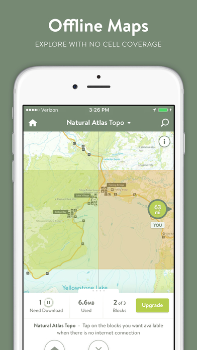
â– OFFLINE MAPS
– Simply tap the blocks (≈10x10mi) you want available offline
– Use 3 offline blocks at any given time for free (enough for most day hikes)
– Upgrade for 250 Blocks (download entire regions)
â– CLOUD SYNC
Your recorded trips and notes (markers) automatically sync to your Natural Atlas account, available online at NaturalAtlas.com. Review & share your trips online with friends, family, and the Natural Atlas community
â– PRO SUBSCRIPTION
Upgrade to Natural Atlas Pro (billed yearly) to get more advanced tools for planning your next adventure:
– Map Printing (PDFs) on NaturalAtlas.com
– 250 Offline Storage Blocks
– Natural Atlas US Public Lands Map (based off BLM SMA data) – Shows FS (including inholdings), BLM, NPS, BIA, Bureau of Reclamation, State, and Private - Designed for the Western USA
– Sunrise, Sunset, Golden Hour Times, Moon Illumination Info
– Private Notes & Trips: Want to note a fishing hole but not publicize it? Mark it as private to make it for your eyes only
– Download GPX Files Online
You can subscribe & pay through your iTunes account. Manage your subscription via the main Settings app: http://support.apple.com/kb/ht4098
Subscriptions auto-renew unless turned off at least 24hrs before the end of the current period. Your iTunes account will be charged for renewal within 24hrs prior to the end of the current period, and identify the cost of the renewal
â– SUPPORT
hello@naturalatlas.com
â– DISCLAIMERS
[Map Coverage] The Natural Atlas Map is United States only (excluding Alaska). The app works fine outside this area, but will show a third-party OpenStreetMap-based map (not available offline)
[Battery Life] We do everything we can to make the app low power when recording, but GPS is notorious for reducing battery life
[Sensitive Places] Notes of certain sensitive topics like petroglyphs are private by default whether you’ve upgraded to Pro or not
Terms: https://naturalatlas.com/terms
Privacy Policy: https://naturalatlas.com/privacy
â– ABOUT US
Built in the Greater Yellowstone Area of WY & MT, Natural Atlas aims to be the premier outdoor map & platform for the US outdoors
Screens